|
Institutul pentru Cercetarea
Patrimoniului Cultural Transilvănean în Context European ACTA TERRAE SEPTEMCASTRENSIS IIISSN 1583-1817 Editura Economică, Sibiu 2003 Autori: Andrei Gonciar, Stephen Batiuk pag.(pages): 95-103.
Geomorfologie
şi topografie digitală a
sitului Gorgan-Apoldul de Jos[1] Andrei Gonciar Stephen Batiuk Summary
The
Apoldu de Jos town is situated in the Miercurea Sibiului commune, in the
administrative district of Sibiu - Romania at 34 km West of the district
capital (Sibiu) on the Miercurea Sibiului – Ludos road, off the Sibiu-Sebes
road. It is part of the Apold (or Apoald) Depression, although it would be
more adequately named the “Miercurea Sibiului Depression”. The depression is
limited to the North by the Secas Plateau (villages of Boz, Drasov, Cunta –
Alba district), to the East by the Aciliul Hills (Apoldu de Jos – Sibiu
district), to the South by the peripheral contact zone of the Sibiu Mountains
and the Sebes Mountains (Poiana Sibiului commune – Sibiu district) and to the
West by the Great Secas Meadows (villages of Calnic, Reciu – Alba district).
The depression is characterized by predominantly low elongated hills, with
gentle slopes and horizontal terraces, grouped in long ensembles. It is
subdivided into two micro-zones linked together by the large Secas meadow:
the first one covers the central zone of the Secas Bassin (confluence of the
Apoldu and Secas rivers) and it is open towards the Sebes Valley, and the
second one is situated at the confluence of the Dobarca, Pustia, Garbova and
Secas rivers. The depression is not sub-mountainous due to the fast rivers
coming down from the Carpathian Mountains perpendicular to the Secas River
moving its the alluvial plane away from the mountains. The relief of the Miercurea Sibiului commune is
mountainous for 2-3 km in the southern part of the region. Separated from the
mountain zone by long and narrow valleys up to 300-400 m wide, a hill
formation extends over 8 km. North of the Secas River, a series of meadows
form the Secas Plateau. Erosion has divided the plateau into several fan
shaped basins converging towards a main valley; the valleys are separated by
low hills 30-200 m wide. Southern and western slopes are relatively steep
(30-60o) and heavily eroded. Some slopes were partially terraced
parallel to contour lines for agricultural purposes. The Apold depression’s morphology is closely
related to its hydrographic structure. It is traversed by the Secas River (42
km), affluent of the Sebes River, a small river with a 20-30 m large bed that
very rarely overflows during heavy rains. The Secas River collects all the
region’s sub-rivers (Sangatin, Amnas, Apold, Dobarca, Pustia, Garbova),
before flowing into the Sebes River. As such it is indirectly connected with
the Mures River hydrographic basin: the Sebes River is an affluent of the
Mures River. In the hill area there are several springs. Except for the areas
of the springs, the water table is relatively deep. The study of the agricultural soils presents two
main categories. The first group, composed of ashy brown soil and alluvial
deposits, is highly fertile. The second group, a significantly less fertile,
is composed of an alluvial silty sand. Other types of soils have been found
in the area, however in small areas. The region is also rich in limestone (Apoldul de
Sus-Varnita, Dobarca-Varnita), marble (Carpinis-Garbova), gravel and sand (in
the various river beds and river platforms), fine clay (Apoldul de Sus -
Gorgan, Apoldul de Sus - Rostat, Miercurea Sibiului-Livadie) deposits. The Apoldu de Jos – Gorgan
site itself is situated on the West side of the Eastern hills that limit the
Secas Depression, 8 km North from Apoldu de Jos, on the Apoldu de Jos – Ludos
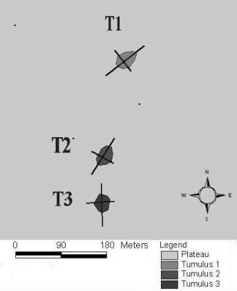
road. It forms a large infra-slope plateau with NE-SW orientation (Fig. 2).
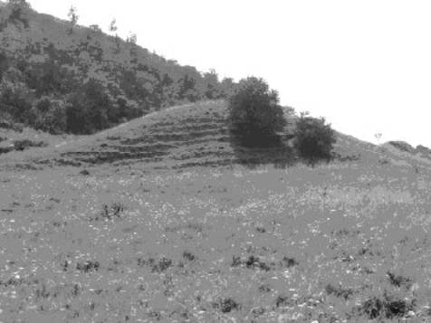
Several large tumular structures (Fig. 1) can be observed near the Eastern
limit of the plateau surrounded by smaller unidentified structure. The large
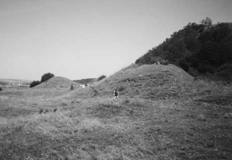
mounds (Photo 1) have been identified, from North to South, in order, as T1
(Photo 2), T2 (Photo 3), T3 (Photo 4). The three main
tumulae are between 8-11m high, they are elongated, roughly aligned SW-NE
with a ramp like structure to the NE (Fig. 1)
The
composition of the mounds, as seen from the excavation of T3, consists of
very fine silt riverine sterile clay. Such material found on such a high
plateau, quite a significant distance from any river/lake bed, solidified the
theory that the mounds were artificial. The sections produced from the
excavation revealed a distinctive stratigraphy of layers of gray-green clay
separated by thin levels of reddish-orange oxidized clay which sloped along
the contours of the mound. It is still at present unclear how to interpret
the red layers. It is unclear whether they are the result of water seeping
into the mound through cracks and running along the natural plains between
the depositional layers, or the result of the oxidization of layers left
temporarily exposed during the construction process of the mound. The later
is more probable given the fact that the red layers for the most part run
horizontally, providing little evidence of water seeping into the surface of
the structure. Furthermore, a significant amount of oxygen would be needed
along with the water to oxidize the clay, necessitating for it to have been
left exposed to the air. Two trenches on the N/NE
side of the mound confirmed that the unusual shape of T3, and by extension
that of T1 and T2, is not the result of natural erosion of the mound, rather
the result of the construction of a ramp-like structure on each tumulus. The
use of such a ramp is unclear. It very well could have been used in the
construction of the mounds, however, it is unclear why they would have been
kept in place afterwards. The excavations produced no evidence for any structures
or any permanent large objects. Due west of T3, small mound like structures
which were hypothesized to be either small, or eroded tumulae, have been
investigated. The feature closest to T3 produced evidence of being a natural
structure. However, it showed that the natural composition of the soil of the
plateau is very different of that of the clay of T3 which confirmed that the
later is not a naturally occurring phenomenon. Of the other three trenches,
only one was brought to any significant depth and is suggestive of the second
feature as being artificial. The
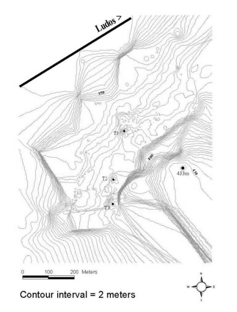
mapping of the plateau (Fig. 2) produced some very interesting and unexpected
results. The archaeological features are actually significantly more complex
than initially suspected. There are three artificially level indentations
into the plateau, the first W/NW of T2, the second E/NE of T2 and the third a
great deal NE of T3, almost at the edge of the plateau. The first two are
quite large approximately 100x20m and the third is small and round approximately
5m in diameter. The first two appear to be linked by some sort of channel
approximately 0.75m wide. The channel clearly connects with the second
feature and runs apparently to the first, but could not be completely traced
and therefore the relationship is still considered as tentative. Given the
channel that is believe to run between them, and the difference in the
vegetation found within the feature (suggestion a greater concentration of
water) it has been suggested that we are looking at some sort of a water
reservoir system. However, given the fact that the features are not very deep
in their present (and very level) state another hypothesis cannot be
discounted. The odd shape of the features does seem reminiscent of the
tumulae already found on the plateau, and it could be suggested that we are
looking at the abandoned preparations for the constructions of new tumulae –
i.e.: the level of the ground. Also
uncovered in the mapping is another channel, or possible roadway which ran
from the first level feature W/NW of T2 leading down to a cut in the edge of
the plateau. Satul Apoldu de
Jos este situat în comuna Miercurea Sibiului, în judeţul Sibiu- România,
la 34 km V de capitala judeţeană (Sibiu), pe ruta Miercurea
Sibiului – Ludoş, în dreapta şoselei Sibiu – Sebeş. Parte din
depresiunea Apold (sau Apoald), ar fi mult mai adecvat să fie
numită depresiunea „Miercurea Sibiului”. Depresiunea este limitată
la N de Podişul Secaşului (satele Boz, Draşov, Cunţa-
judeţul Alba), la E de Dealurile Aciliului (Apoldu de Jos – judeţul
Sibiu), la S de zona periferică de contact a Munţilor Sibiului
şi a Munţilor Sebeşului (comuna Poiana Sibiului – judeţul
Sibiu) şi la V de marea luncă a Secaşului (satele Câlnic,
Reciu – judeţul Alba). Depresiunea este caracterizată de
predominarea dealurilor joase şi lungi, cu pante line şi terase
orizontale, grupate în ansambluri lungi. Ea este subdivizată în
două micro-zone unite de marea luncă a Secaşului: prima
acoperă zona centrală a Bazinului Secaş (confluenţa
râurilor Apoldu cu Secaş) şi este
deschisă înspre valea Sebeşului, şi a doua este
situată la confluenţa râurilor Dobârca, Pustia, Gârbova şi
Secaş. Depresiunea nu este submontană datorită râurilor repezi
care coboară din Munţii Carpaţi perpendicular pe râul
Secaş deplasând platoul aluvial departe de munţi. Morfologia
depresiunii Apold este strâns legată de structura sa hidrografică.
Ea este traversată de râul Secaş (42 km) afluent al Sebeşului,
un râu mic cu o albie de 20–30 m care iese foarte rar din matcă în timpul
ploilor. Râul Secaş adună toate râurile regiunii (Sângatin,
Amnaş, Apold, Dobârca, Pustia, Gârbova), înainte de a se vărsa în
râul Sebeş. El este indirect legat cu bazinul hidrografic al râului
Mureş: râul Sebeş este un afluent al râului Mureş. În regiunile
de deal el are câteva izvoare. Exceptând aceste izvoare, reţeaua de
apă freatică este la o adâncime apreciabilă. Situl Apoldu de
Jos – Gorganu este situat în partea de V a dealurilor estice care
limitează depresiunea Secaşului, 8 km N de Apoldu de Jos, pe drumul
Apoldu de Jos – Ludoş. Situl este prezentat printr-un larg platou
orientat NE-SV (foto 1). Se pot observa câteva mari structuri tumulare (fig.
1) lângă limita estică a platoului, înconjurate de câteva structuri
mici, neidentificate.Cei trei tumuli principali au fost identificaţi, de
la N către S, în ordine, ca T1 (foto 2), T2 (foto 3) şi T3 (foto
4). Ei măsoară între 8 şi 11m în înălţime, au o
structură alungită orientată aproximativ SV-NE cu o
structură în forma de rampă către NE (fig. 2). Compoziţia
movilelor constă într-o pastă de nisip fin provenind din albia
râului. Astfel de material găsit, pe asemenea, pe platoul înalt, la o
distanţa semnificativă de orice albie de râu / lac,
întăreşte teoria potrivit căreia movilele sunt artificiale.
Secţiunile produse prin excavarea lui T3 au relevat o stratigrafie
distinctă a straturilor de lut verde–gri separate de niveluri
subţiri de lut oxidat roşiatic–portocaliu care cade în pantă
de-a lungul conturului movilei. Este încă prezentă problema
interpretării straturilor roşii. De asemenea, este discutabil
dacă ele sunt rezultatul infiltraţiilor apei în movilă prin
fisuri, scurgerea ei de-a lungul suprafeţelor naturale printre straturi,
ori ca un rezultat a oxidarii straturilor expuse temporar în timpul
procesului de construire a movilei. Ultima este cea mai probabilă
teorie, dată de faptul că straturile roşii, în cea mai mare
parte, sunt dispuse orizontal, furnizând o mică dovadă a apei
prelinse pe suprafata structurii. În plus, ar fi fost necesară o
semificativă cantitate de oxigen, împreună cu apa scursă,
pentru a oxida argila, iar pentru aceasta trebuia să fi fost
lăsată în aer liber. Forma
neobişnuită a lui T3, şi prin extensiune cea a lui T1 si T2,
nu este urmarea eroziunii naturale a movilei, mai degrabă fiind
rezultatul construcţiei structurii unei rampe pentru fiecare tumul.
Folosirea unei asemenea rampe nu este lamurită. La fel de bine ar fi
putut fi folosită pentru construcţia movilelor, oricum, este neclar
de ce acestea ar fi fost menţinute acolo şi după terminarea
construcţiei. La V de T3 a fost
cercetată o mică movilă a cărei structură a dus la
concluzia că era fie un tumul mic, fie unul erodat. Construcţia,
apropiată ca sistem de T3, probează a fi o structură
naturală. Însă s-a arătat că, compoziţia
naturală a solului platoului este foarte diferită de cea a lutului
din T3, ceea ce a confirmat că ultima observaţie nu arată un
fenomen întâmplător. Harta platoului a
fost facută cu ajutorul unui Topcon Model 312 Total Station. Reperele au
fost luate la fiecare 1–1,5m de-a lungul liniei generale E–V. Mai multe
puncte de reper au fost luate pe structurile specifice, încercând să le
definim mai precis într-un mediu tridimensional. Însă, dată fiind
diferenţa mare în înălţime dintre structurile artificiale
şi cele naturale, harta generală topografică nu a putut reda
şi cele mai mici structuri făcute de om. S-au produs câteva
rezultate neaşteptate şi interesante. Construcţiile
arheologice sunt acum mai complexe decât s-a crezut iniţial. Acolo sunt
trei niveluri artificiale incluse în platou, primul V-NV de T2, al doilea
E-NE de T2 şi al treilea cu o mare orientare NE de T3, aproape de
marginea platoului. Primele două sunt destul de mari, aproximativ 100 x 20 m şi al
treilea este mic şi circular, aproximativ 5 m în diametru. Primele
două par să fie legate de un fel de canal de aproximativ 0,75 m
lărgime. Evident, canalul se leagă cu a doua structură şi
merge, aparent, către prima, dar nu a fost complet trasat şi de
aceea legătura este considerată doar o „tentativă”.
Datorită faptului că aparent canalul trece printre ele, şi a
vegetatiei diferite găsită în construcţie (sugerând o mare
concentraţie de apă), se ajunge la concluzia că avem în
faţă un sistem, un rezervor de apă. În orice caz, dat fiind
faptul că construcţiile în prezent nu sunt prea adânci (foarte
netede), afirmarea unei alte ipoteze nu poate fi luată în considerare.
Forma ciudată a construcţiei pare să fie o
reminiscenţă a tumulilor deja găsiţi pe platou şi
poate sugera că ceea ce avem în faţă sunt pregătirile
abandonate ale construcţiei unui nou tumul – i.e.: nivelul
pământului. De altfel, fără să apară pe hartă,
este un alt canal, sau un posibil drum care merge de la primul nivel al
construcţiei V-NV, tăind T2 la marginea platoului. Continuarea
cartografierii este necesară pentru a ilustra precis legăturile
dintre structuri şi a cizela harta însăşi. De asemenea, o
cartografiere intensă şi precisă a fost condusă
către structurile artificiale mai mici, în ordine, pentru a le integra
în ansamblu. În orice caz, regiunea dintre drum şi marginea platoului ar
trebui să fie o prioritate. Au fost adunate date insuficiente din
această arie în timpul sezonului 2001 din cauza lipsei de timp, fiind
schiţată sumar partea de SE a
hărţii drumului. Totuşi, acea arie prezinta o
caracteristică complexă a construcţiilor, artificiale sau
naturale.
Fig. 1: Poziţie
şi orientare relativa a principalilor trei tumuli. Relative
position and orientation of main tumulae.
Fig. 2: Hartă topografică
a sitului tumular de la Apoldu de Jos-Gorganu.
Contour map of the Apoldu de Jos-Gorganu tumular
site.
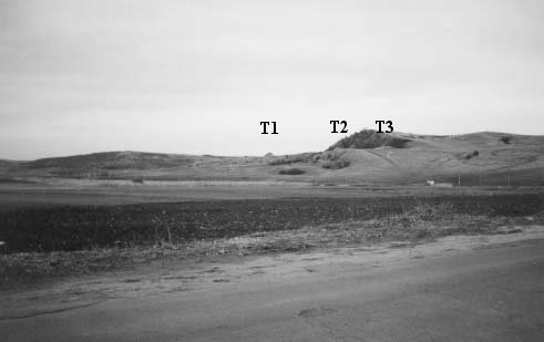
Foto 1: Vedere dinspre E-SE a platoului Gorganu. View of the Gorganu plateau – view from the East-Southeast.
Foto 2:
Vedere dinspre S a tumului 1. Tumulus 1
– view from the South.
Foto 3: Vedere dinspre N a tumului 3. Tumulus 2 –
view from the North
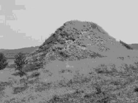
Foto 4: Vedere dinspre S-SV a tumului 3
(prim-plan) şi a tumului 2 (plan îndepărtat). Tumulus 3 (foreground)
and tumulus 2 (background) – view from the South-Southwest.
|